
চিত্র:MSH80 mudline muddy river with USGS scientist 10-23-80.jpg

এই প্রাকদর্শনের আকার: ৮০০ × ৫৩৬ পিক্সেল। অন্যান্য আকারসমূহ: ৩২০ × ২১৫ পিক্সেল | ৬৪০ × ৪২৯ পিক্সেল | ১,০২৪ × ৬৮৭ পিক্সেল | ১,২৮০ × ৮৫৮ পিক্সেল | ২,৯০৪ × ১,৯৪৭ পিক্সেল।
পূর্ণ রেজোলিউশন (২,৯০৪ × ১,৯৪৭ পিক্সেল, ফাইলের আকার: ২.৬৪ মেগাবাইট, এমআইএমই ধরন: image/jpeg)
| এই ফাইলটি উইকিমিডিয়া কমন্স থেকে নেওয়া। সেখানের বর্ণনা পাতার বিস্তারিত নিম্নে দেখানো হলো। (সম্পাদনা)
|
সারাংশ
| বিবরণ |
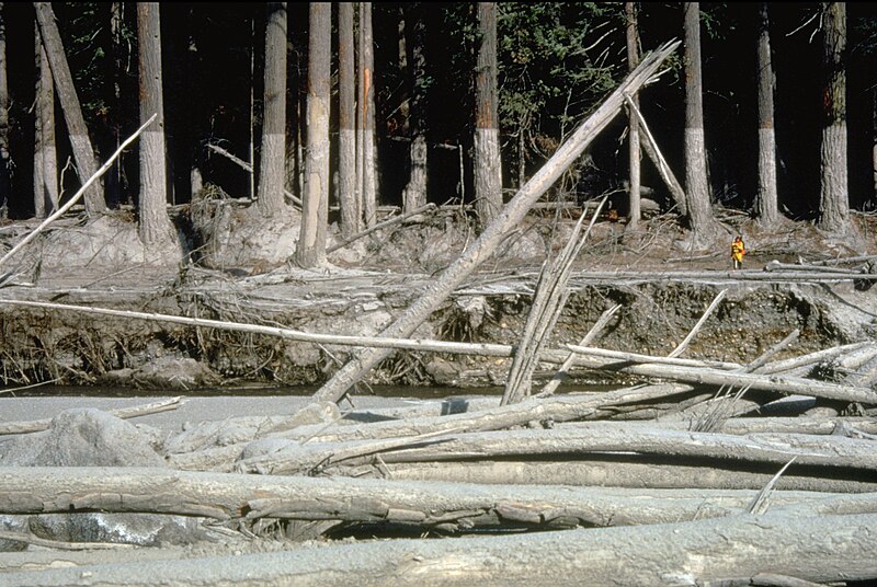
English: (copied description from USGS site): Nearly 135 miles (220 kilometers) of river channels surrounding the volcano [Mt. St. Helens] were affected by the lahars of May 18, 1980. A mudline left behind on trees shows depths reached by the mud. A scientist (middle right) gives scale. This view is along the Muddy River, southeast of Mount St. Helens. |
| তারিখ | তোলা হয়েছে ২৩ অক্টোবর ১৯৮০ |
| উৎস | http://vulcan.wr.usgs.gov/Glossary/Lahars/description_lahars.html |
| লেখক | Lyn Topinka, USGS |
লাইসেন্স প্রদান
This image is in the public domain in the United States because it only contains materials that originally came from the United States Geological Survey, an agency of the United States Department of the Interior. For more information, see the official USGS copyright policy.
|
ফাইলের ইতিহাস
যেকোনো তারিখ/সময়ে ক্লিক করে দেখুন ফাইলটি তখন কী অবস্থায় ছিল।
| তারিখ/সময় | সংক্ষেপচিত্র | মাত্রা | ব্যবহারকারী | মন্তব্য | |
|---|---|---|---|---|---|
| বর্তমান | ০৩:৩৫, ১২ ডিসেম্বর ২০২২ | | ২,৯০৪ × ১,৯৪৭ (২.৬৪ মেগাবাইট) | Hike395 | less jpeg compression, re-crop from original |
| ০২:৩২, ১০ অক্টোবর ২০১১ |  | ২,৯১৬ × ১,৯৪৮ (১.২১ মেগাবাইট) | Materialscientist | crop frame | |
| ১৫:০২, ২ সেপ্টেম্বর ২০১০ |  | ৩,০৭২ × ২,০৪৮ (৪.০৭ মেগাবাইট) | Awickert | {{Information |Description={{en|1=(copied description from USGS site): Nearly 135 miles (220 kilometers) of river channels surrounding the volcano [Mt. St. Helens] were affected by the lahars of May 18, 1980. A mudline left behind on trees shows depths re |
সংযোগসমূহ
নিচের পৃষ্ঠা(গুলো) থেকে এই ছবিতে সংযোগ আছে:
ফাইলের বৈশ্বিক ব্যবহার
নিচের অন্যান্য উইকিগুলো এই ফাইলটি ব্যবহার করে:
- bg.wikipedia.org-এ ব্যবহার
- cs.wikipedia.org-এ ব্যবহার
- de.wikipedia.org-এ ব্যবহার
- en.wikipedia.org-এ ব্যবহার
- es.wikipedia.org-এ ব্যবহার
- fr.wikipedia.org-এ ব্যবহার
- he.wikipedia.org-এ ব্যবহার
- id.wikipedia.org-এ ব্যবহার
- it.wikipedia.org-এ ব্যবহার
- nl.wikipedia.org-এ ব্যবহার
- oc.wikipedia.org-এ ব্যবহার
- ro.wikipedia.org-এ ব্যবহার
- sk.wikipedia.org-এ ব্যবহার
- sv.wikipedia.org-এ ব্যবহার
- tr.wikipedia.org-এ ব্যবহার
- uk.wikipedia.org-এ ব্যবহার
- vi.wikipedia.org-এ ব্যবহার
- www.wikidata.org-এ ব্যবহার
- zh.wikipedia.org-এ ব্যবহার