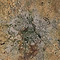
চিত্র:New Delhi, India ESA23519559.jpeg

পূর্ণ রেজোলিউশন (৫,৫৮৬ × ৫,৫৮৬ পিক্সেল, ফাইলের আকার: ১২.২ মেগাবাইট, এমআইএমই ধরন: image/jpeg)
| এই ফাইলটি উইকিমিডিয়া কমন্স থেকে নেওয়া। সেখানের বর্ণনা পাতার বিস্তারিত নিম্নে দেখানো হলো। (সম্পাদনা)
|
সারাংশ
| বিবরণNew Delhi, India ESA23519559.jpeg |
English: New Delhi, the capital and second-largest city of India, is featured in this image captured by the Copernicus Sentinel-2 mission. Zoom in to see this image at its full 10 m resolution or click on the circles to learn more about the features in it. New Delhi is situated in the north-central part of the country and lies within the massive metropolitan area of Delhi, India’s capital territory. To the east, Delhi is bounded by the state of Uttar Pradesh, and to the north, west and south it is bounded by the state of Haryana. Delhi’s urban area consists of the historical city of Old Delhi in the north, New Delhi in the south and now also includes the nearby cities of Ghaziabad, Faridabad, Gurugram and Noida. From space, these cityscapes together appear light grey in tone. New Delhi sits, primarily, on the west bank of the Yamuna River, visible in black in the right of the image. One of the country’s most sacred rivers, the Yamuna is a tributary of the Ganges River, located around 160 km south of the Himalayas. New Delhi, the government, commercial and financial centre of India, is considered one of the fastest growing cities in the country and in the world. The straight and diagonal pattern of the broad, tree-lined avenues in New Delhi, which features extensive green spaces, makes it appear as a darker-toned region and contrasts with the narrower, winding streets of Old Delhi. The city is dotted with numerous museums, monuments, botanical gardens, places of worship and cultural buildings including the Hindu Akshardham Temple. Other notable features in the image include Indira Gandhi International Airport visible in the left, and Hindon Airport to the right. Some perfectly squared plots of land can be seen in the image, particularly in the west side of the city. As well as providing detailed information about Earth’s vegetation, Copernicus Sentinel-2 is designed to play a key role in mapping differences in land cover to understand the landscape, map how it is used and monitor changes over time. As cities continue to expand, Sentinel-2 can also be used to track urban expansion and assist urban planners. This image is also featured on the Earth from Space video programme. |
| তারিখ | ১৫ অক্টোবর ২০২১ (আপলোডের তারিখ) |
| উৎস | New Delhi, India |
| লেখক | European Space Agency |
| অন্যান্য সংস্করণ |
|
| Activity InfoField | Observing the Earth |
| Mission InfoField | Sentinel-2 |
| Set InfoField | Earth observation image of the week |
| System InfoField | Copernicus |
লাইসেন্স প্রদান

|
This image contains data from a satellite in the Copernicus Programme, such as Sentinel-1, Sentinel-2 or Sentinel-3. Attribution is required when using this image.
স্বীকৃতিপ্রদান: Contains modified Copernicus Sentinel data 2021
Attribution
The use of Copernicus Sentinel Data is regulated under EU law (Commission Delegated Regulation (EU) No 1159/2013 and Regulation (EU) No 377/2014). Relevant excerpts:
Free access shall be given to GMES dedicated data [...] made available through GMES dissemination platforms [...].
Access to GMES dedicated data [...] shall be given for the purpose of the following use in so far as it is lawful:
GMES dedicated data [...] may be used worldwide without limitations in time.
GMES dedicated data and GMES service information are provided to users without any express or implied warranty, including as regards quality and suitability for any purpose. |
Attribution
This media was created by the European Space Agency (ESA).
Where expressly so stated, images or videos are covered by the Creative Commons Attribution-ShareAlike 3.0 IGO (CC BY-SA 3.0 IGO) licence, ESA being an Intergovernmental Organisation (IGO), as defined by the CC BY-SA 3.0 IGO licence. The user is allowed under the terms and conditions of the CC BY-SA 3.0 IGO license to Reproduce, Distribute and Publicly Perform the ESA images and videos released under CC BY-SA 3.0 IGO licence and the Adaptations thereof, without further explicit permission being necessary, for as long as the user complies with the conditions and restrictions set forth in the CC BY-SA 3.0 IGO licence, these including that:
See the ESA Creative Commons copyright notice for complete information, and this article for additional details.
|
 | |
এই ফাইলটি ক্রিয়েটিভ কমন্স অ্যাট্রিবিউশন-শেয়ারঅ্যালাইক ৩.০ আইজিও লাইসেন্সের আওতায় লাইসেন্সকৃত। স্বীকৃতিপ্রদান: ESA, CC BY-SA IGO 3.0
| ||
ক্যাপশন
এই ফাইলে চিত্রিত আইটেমগুলি
যা চিত্রিত করে
image/jpeg
ফাইলের ইতিহাস
যেকোনো তারিখ/সময়ে ক্লিক করে দেখুন ফাইলটি তখন কী অবস্থায় ছিল।
| তারিখ/সময় | সংক্ষেপচিত্র | মাত্রা | ব্যবহারকারী | মন্তব্য | |
|---|---|---|---|---|---|
| বর্তমান | ১৭:৪৫, ১৮ অক্টোবর ২০২১ |  | ৫,৫৮৬ × ৫,৫৮৬ (১২.২ মেগাবাইট) | Don-vip | high-res JPEG version from TIFF file |
| ১৫:৫২, ১৮ অক্টোবর ২০২১ |  | ২,২৩৪ × ২,২৩৪ (১.৫৪ মেগাবাইট) | OptimusPrimeBot | #Spacemedia - Upload of https://www.esa.int/var/esa/storage/images/esa_multimedia/images/2021/10/new_delhi_india/23519548-2-eng-GB/New_Delhi_India.jpg via Commons:Spacemedia |
সংযোগসমূহ
নিচের পৃষ্ঠা(গুলো) থেকে এই ছবিতে সংযোগ আছে:
ফাইলের বৈশ্বিক ব্যবহার
নিচের অন্যান্য উইকিগুলো এই ফাইলটি ব্যবহার করে:
- fr.wikipedia.org-এ ব্যবহার


